▼ Introduction of Oshima Island Branch Office
▼ The organization of the Oshima Island Branch Office
▼ Towns-and-villages information in a branch office pipe
Introduction of Oshima Island Branch Office
- The outline in the Oshima Island Branch Office pipe is introduced.
The Oshima Island Branch Office makes the jurisdiction five islands in Oshima, Toshima, Niijima, Shikinejima, and Kozushima among Izu Islands.From Tokyo, the northernmost Oshima is in on the ocean [ about 109-km ] to south, and stands in a row in order of Toshima, Niijima, Shikinejima, and Kozushima to it.The organization of the Oshima Island Branch Office consists of the general affairs division, an industrial division, the civil engineering division, Harbor Unit, a Niijima branch office, and a Kozushima branch office, and each island in Oshima, Niijima, and Kozushima is dotted with the office. 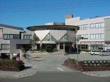
Oshima Island Branch Office
Any island holds the variegated and rich nature which changes to all seasons, and charms many people earnestly.Abundant fish and shellfishes can reach a table through every year, and can enjoy a hot spring everywhere by a volcanic benefit.Many tourists who especially enjoy marine sports to Oshima, Niijima, and Kozushima in a summer season come.
From 2002, the jetfoil went into commission on each island, and the time required from Tokyo was shortened sharply.
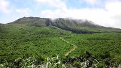
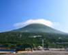
Mt.Mihara- But the inside of the Oshima pipe is also the disaster-prone nature of the locality so that it may be represented by a volcano and the typhoon.The full evacuation from the island by the eruption of Mt. Mihara in 1986 is a place fresh in memory.Moreover, Niijima and the earthquake at the sea near Kozushima which occurred in 2000 brought about serious damage, such as a road and a landslide.
The role of the Oshima Island Branch Office promotes the community improvement in which the characteristic of such an island was employed efficiently, and there is in aiming at improvement and stability of a resident life.Therefore, it aims at the thing which advances infrastructure improvement of the agriculture which employed the characteristic of (1) island efficiently, and a fishing, and attains activation of the tourist industry which is a major industry, which promotes maintenance of (2) prefectural roads, an airport, and a port, and aims at substantial traffic access and for which a community improvement strong against (3) disasters is advanced.
The organization of the Oshima Island Branch Office
I show around about the organization of the Oshima Island Branch Office.
| Oshima Island Branch Office | General Affairs Section...Personnel affairs, a budget, property Industry Section...Commerce and industry, Agriculture, forestry, fishery Civil Engineering Section...Construction, the measure against a lava flow, a lot Harbor Section...Construction, port airport management |
| Oshima Island Park Office | Park management |
| Oshima port airport administration office | A port, a fishing port, airport management |
| Niijima Branch Office | General affairs, industry, engineering works, a port |
| Niijima port airport administration office | A port, a fishing port, airport management |
| Kozushima Branch Office | General affairs, industry, engineering works, a port |
| Kozushima port airport administration office | A port, a fishing port, airport management |
Oshima-Town
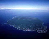
- Oshima is about 9 km of east and west, 15 km of north and south, and about 52 km of circumferences, and area is 91.06 square meter.It is the greatest island in Izu Islands, and the most is formed qualitatively of basalt.There is a crater basin (caldera) called desert of a 10 Square kilometer of an island mostly surrounded by the somma in the center degree, and 764 m (central cone) of Mt. Mihara is in this.Although the east side of Oshima is a precipitous cliff, the slope of the west side is loose and the flat ground has opened it.It is covered with the all-of-the-island forest except for the central crater basin, and Six colonies in Oshima are developed along the seashore.
Toshima-Village
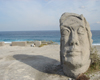
- There is Toshima on the sea of about 28 km of south directions in Oshima.It is an islet of 8 km of circumferences, and area abbreviation 4.12 square kilometer, in the seashore, a cliff continues, there is no flat ground, and mountain side north slippage has a colony.Although it consists of the quality of basalt, plainness is over topsoil most all over Izu Islands, most all of the island is covered by a camellia, and the group of "Kathuodori" is seen.
Niijima-Village
- Niijima has on the sea about 44 km south-southwest of Oshima, and, in the east-and-west central part on the island of about 2 km in width, about 11.5 km of north and south, 28 km of circumferences, and area abbreviation 23.87 square kilometer which carried out the gourd form mostly.Unlike Oshima, it is formed with rhyolite.Mukoyama has upheaved in the south of an island, and The highest Mt. Miyatsuka in Niijima and the Niijima mountain which stands in a row in it rise high over the northern part. an island -- the flat ground opens the central part in east and west mostly, the west side seashore is faced, and there is "Honson"'s colony. The maximum northern part of the island and the foot of Niijima are faced in West Coast, and there is a colony of "Wakagou".The west side coastline is called a front beach and is the largest sands in Izu Islands. "Habushiura" of East Coast is formed at sand with the about 5km white coastline, and the cliff which shines white.
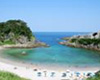
- Shikinejima is an island which is located on the sea of about 8 km of Niijima's south directions, and belongs to Niijima.The circumference of the island is about 12 km, and area is 3.90 square kilometer.Most geographical features are common log deck places, and the upheaved high ground is not seen.The coastline is surrounded on a bluff.It is most varied in Izu Islands, there are many small bays, and it is blessed with unparalleled views, such as white sand, a blue pine and strangely shaped rocks.Two natural open-air baths are located on the southeast part seashore of an island.Unlike other islands, colonies are scattered in here and there of an Shikinejima island.
Kozushima-Village
- There is Kozushima on the sea of about 25 km of Niijima's south directions,it is at the center mostly of Izu Islands.Area of Kozushima is about 18.87 square kilometer in about 4 km of east and west, about 8 km of north and south, and about 22 km of circumferences."Mt.Tenjosan" rises in the center of an island, and "Mt.Koshosan" and "Mt.chichibuyama" range from the center of the island like the back of a camel to south."Kouzu-Sawa" which emits a source to "Mt.Tenjosan" is the greatest Sawa in Izu Islands, although there is little water usually, a muddy stream may overflow in the case of a heavy rain.The coastline of the lower stream is surrounded on a bluff, the seashore in front of a colony has only opened slightly. Here is the Kozushima harbor using a reef.
> GO TOKYO -Official Tokyo Travel Guide- ![]() > Niijima-village Homepage
> Niijima-village Homepage ![]() > Tokai Kisen co.,Ltd
> Tokai Kisen co.,Ltd ![]()